Showing posts with label Townsville. Show all posts

Sunday, 24 April 2022

Freshwater & Lagoon Trails

Town Common Conservation Park - Townsville

Acknowledging the Bindal and Wulgurukaba people as the traditional owners and first people to live in the Townsville region for thousands of years and many generations.

The Freshwater and Lagoon trails form a 7.2 km circuit around the coastal wetlands of the Town Common Conservation Park.  Located a short 7km drive from Townsville CBD, turning off Cape Pallarenda Road at Rowes Bay Golf Course, you follow the unsealed road for another 5km to reach the Town Common nature reserve.

This place is a paradise for wetland birdlife

Sharing this waterhole are spoonbills, egrets, heron and ibis

 Pelicans are part of the scene

Beautiful Brolgas

200m walk from the Town Common carpark is Freshwater Bird Hide overlooking the wetlands.  
More than 300 bird species have been recorded in the wetlands of Town Common. (1)


Magpie Goose


White-face Heron

Intermediate Egret

Pied Cormorant

The trail is shared between hikers and mountain bikers

Bald Rock - Mount Marlow


The wetlands have formed over thousands of years.  In recent history, the area was gazetted in 1869 as common land for the people of Townsville, and was used for cattle grazing and to spell horses.  Town Common became a conservation park in 1983.

References

1. Birds of the Townsville Region - City of Townsville
https://www.townsville.qld.gov.au/__data/assets/pdf_file/0027/79704/Birdwatching-16ppDL-web.pdf


Saturday, 26 February 2022

Mount Louisa Bush Walking Track

 Acknowledging the Bindal and Wulgurukaba people as the Traditional Owners and first people to live in the Townsville Region for thousands of years and many generations.

Mount Louisa Bush Walking Track is popular amongst fitness enthusiasts, providing a great opportunity to get fit outdoors.  Located 11km north of Townsville's CBD, the track starts from suburban Weston Street, Mount Louisa.  

The 3.5km circuit track contains many stair climbs along the way to reach the summit and enjoy sweeping views to the north-east across Townsville and Cleveland Bay out to Magnetic Island, as well as views from the ridgeline and summit extending south-west from Mount Stuart to Kirwan.

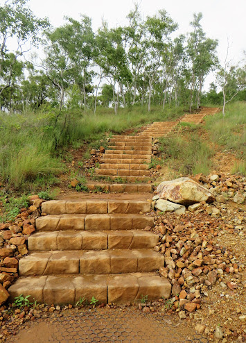
About 100m from the start of the track, you come to the first set of steps.  
Now you get a good idea of what you have signed up for.
This is a Class 3 walking track containing steep grades, loose surfaces, uneven steps and minimal infrastructure.  The walk provides a good workout and rewarding hill summit experience. 
 
About 1km along the trail you have a choice to make...
Take the 650m stair climb to the summit, a short cut with high intensity,
or
Continue up the trail for 1.7km, almost 3 times the distance to reach the top, still huffing & puffing from stair climbs along the way, but more gradual paths making it less physically intense.
 
The track officially opened in October 2020 after a $2.2M investment from Townsville City Council. The trail was designed in consultation with a local track expert, Peter McLean, built by JMAC Constructions and incorporates stone steps supplied by Edenstone Masonry NQ. (1)
According to interpretive signs along the track, the Bindal and Wulgurukaba people, as traditional owners, named the area Goo-bal-a-boro and Moor-ee-roon.  The European name of Mount Louisa was given in 1864 by local explorer Andrew Ball, after a lady of his acquaintance, although nothing else is known about the lady.

Seating and interesting interpretive signage along the way.
Interpretive signage tells the stories of this area over recent history.  Mount Louisa wasused during WWII as an extension to the aerodrome located in neighbouring Garbutt, and as a station for US defence forces.  In 1959, the land was purchased by the Fairbrother family for a pig farm.
There is a total of 1,700 steps along the trail.
Excellent views across suburban Mount Louisa, neighbouring Garbutt, 
across to Cape Pallarenda, Cleveland Bay and Magnetic Island

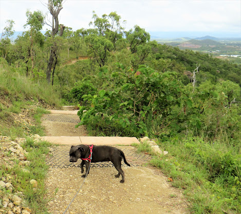
Dogs on leads are permitted

Rainbow Bee-Eaters are found throughout mainland Australia, southern birds will fly north for winter.  They eat mainly bees and wasps, as well as butterflies, moths, dragonflies and beetles.  When they catch a bee or wasp, the Rainbow Bee-Eater will carry it's catch back to a perch and rub it against the perch to remove the stings and venom before eating it.  These birds build nesting tunnels in sandy banks and line their tunnel with grass. (2)


Pheasant Coucal

Reaching the summit of Mount Louisa Bush Walking Track is an achievement 
with 360 degree views as the reward.

References:

1. Townsville City Council, Media Release, 2 October 2020

https://www.townsville.qld.gov.au/about-council/news-and-publications/media-releases/2020/october/on-your-marks-get-set-go-new-mount-louisa-walking-trail-to-open

2. Birdlife Australia

https://www.birdlife.org.au/bird-profile/rainbow-bee-eater

Saturday, 22 January 2022

Crystal Rockslides & Big Crystal Creek

Acknowledging the Nwyaigi people as the Traditional Owners and first people to live in the Paluma Region for thousands of years and many generations.

Paluma Range National Park is located about an hour's drive (70km) north of Townsville with easy access to freshwater swimming holes for day trips and camping at Big Crystal Creek. 

Crystal Rockslides are located just 2km past Big Crystal Creek Campgrounds, taking a narrow and sealed road to reach the ample carpark areas.   From here, its a short 500m walk on sealed surfaces, with an uphill section before taking the shady path to reach the Rockslides. 

    Crystal Rockslides is great for cooling off, having fun and enjoying the Paluma experience

It's an easy walk to reach the Rockslides

When you get there, mind the steps
                   

Towering rockfaces and boulders of granite and granodiorite surround the natural pools and waterfalls that form Crystal Rockslides (1).  Granite and granodiorite are types of intrusic rock formed deep below the earth's surface when volcanic magma has been forced into older rocks and slowly cools and solidifies (2).  These ancient rock formations are the mountain roots which have eventually reached the earth's surface through erosion (3 & 4).
Leaping off natural rock platforms into the pool below provides hours of entertainment.
This is not for the faint-hearted.
Those looking for a quick rush of adrenalin will enjoy the fun of rock jumping. 
Beginners start with a jump of about 3m, 
before graduating to jump about 7m from the higher rock.
Even if rock jumping isn't your thing, it makes for good spectating 
and is a memorable part of every visit to Crystal Rockslides.  
Please remember:  SAFETY FIRST!
The traditional name for Paluma Range is Munan Gumburu, which means 'misty mountain'


When you finish exploring Crystal Rockslides, head back to Big Crystal Creek day-use area for a barbeque or picnic in the shady park.  Take a short walk to Paradise Waterhole for a final swim.
Paradise Waterhole - Big Crystal Creek


Pheasant Coucal

A member of the cuckoo family, the pheasant coucal is one of Australia's largest cuckoo species.

Pheasant coucals are found across north-eastern Australia, from the Pilbara in WA to Southern NSW, and also in the Torres Strait islands, Timor and Papua New Guinea.  They especially enjoy the canefields, tropical forests and mangroves of North Queensland.

Cuckoos are 'parasitic' birds that lay their eggs in the nests of other birds.  However the pheasant coucal is an exception, as the only Australian species of cuckoo to lay eggs in it's own nest.

Pheasant coucals are ground dwelling and feed on large insects, frogs, lizzards, eggs and small mammals.  They build their nests on the ground with long stems of grass to form a dome shape. (7)

Australian Brush-turkey

Crystal Rockslides - upper section

References
(1) Department of National Parks, Recreation, Sport & Racing; Paluma Range National Park Management Statement 2013;
https://parks.des.qld.gov.au/__data/assets/pdf_file/0018/167004/paluma-range.pdf
(2) Britannica 
https://www.britannica.com/science/intrusive-rock
(3) University of Auckland https://flexiblelearning.auckland.ac.nz/rocks_minerals/rocks/granodiorite.html
(4) US National Parks Service
https://www.nps.gov/goga/learn/education/granite-and-granodiorite-faq.htm
(5) UNESCO World Heritage Centre
https://whc.unesco.org/en/list/486/
(6) Wet Tropics Management Authority
https://www.wettropics.gov.au/world-heritage-area-facts-and-figures.html
(7) Australian Geographic
https://www.australiangeographic.com.au/blogs/creatura-blog/2018/03/the-pheasant-coucal-is-proof-that-australia-has-the-best-birds/